Precision Agriculture Solutions
(PLEASE USE INNER SCROLL BAR AT RIGHT TO VIEW ENTIRE ARTICLE)
Typically, healthy plants are green. Withhold water and they brown. Long before the stress factors that endanger plants can be seen in the visible spectrum, they appear in the near-infrared.
Tetracam's imaging systems monitor the visible and near infrared radiation that plants reflect. This enables our customers to capture the data they need to react to problems caused by extreme climate changes; weeds, pests and diseases; over-planting; improper irrigation; inconsistent application of fertilizers; poor drainage and, a host of other problems that impact the health of crops.
Ground-based imaging systems and imaging systems that are carried in low-flying aircraft have distinct advantages over satellite-based monitoring systems. Their views are less likely to be hindered by clouds. They are less prone to errors due to atomospheric perturbations, Raleigh scattering, smoke or air pollution. Near-Earth images may be captured over and over again in a timely manner under the complete control of the user. And, images from satellites that are of comparable resolution to those captured by near-Earth systems are expensive.
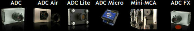
The cameras in the ADC (Agriculture Digital Camera) family of imaging systems contain a single high-resolution image sensor. The sensor is divided into a mosaic of filters. Each filter allows either red, green or near-infrared radiation to pass through.
Each ADC system includes PixelWrench2 software. By adding the filtered light from each pixel output from the sensor, PixelWrench2 is able to convert the captured color infrared (CIR) image into one of a number of standard graphical indicators such as NDVI (Normalized Difference Vegetative Index) or SAVI (Soil-Adjusted Vegetation Index). Indices such as these indicate biomass, chlorophyll content and the overall health of plants.
Tetracam's MCA (Multiple Camera Array) family of imaging systems contain multiple high-resolution image sensors. These cameras are available in groups of 4, 6 or 12 sensors. Cameras may be cascaded together or individual sensors may be removed to provide the precise number of sensors required.
Each MCA sensor is fronted by a narrow band optical filter. The filter limits the radiation able to pass through it to a narrow band of specific wavelengths, typically in the area of 10 nm wide. By monitoring combinations of filtered wavelengths, MCA cameras enable users to look for a specific compound such as nitrates found in fertilizer or a specific type of vegetation, each identifiable by a unique spectral signature.
The narrow band filters that cover each sensor are selectable at the time of order. Scientific articles and agronomic references such as those included on our website in our Multispectral Crop and Application Database or the Selected Readings shown under the Support section of our site discuss filter combinations commonly used in precision agriculture.
Each of the filters on Mini-MCA systems may be replaced in the field anytime users require their system to monitor a different set of conditions. Filter that pass common bands that are useful for work with vegetation (for example, those that allow extraction of NDVI, SAVI and other common vegetation indices) are included in the price of the Mini-MCA. Alternative band pass filters are available upon request with prices provided via a quotation. Click here for additional information on band pass filters for the Mini-MCA.
Low-lying crops such as alfalfa or barley may be monitored by cameras located on fixed or mobile telescopic masts. For taller vegetation, in order not to sacrifice accuracy in extracting NDVI and other vegetative indices, a nadir viewing angle is recommended. For this reason, many of our cameras are carried aboard low flying manned and unmanned aircraft. We provide an aerial photography service using our own plane and pilots for customers in the Southern and Central California area. We also bundle our systems with our own unmanned aerial systems (UAS) and those of others.
Our Hawkeye parafoil is a UAS that is remarkable for its ease of operation. The Hawkeye is designed to operate in calm weather conditions (where wind gusts are below 20 MPH). The craft contains an innate safety feature that provides protection against damage in case of mechanical malfunction. With its parafoil always deployed, if its motor should fail, the Hawkeye is designed to simply float to the ground, minimizing damage to itself and its payload. The Hawkeye's purchase price is also considerably lower than most competitive UAS camera platforms currently on the market so it is an excellent solution for small farms and research sites with limited area.
SensorLink is software that enables our cameras to snap pictures at specific GPS locations so the entire flight may be pre-programmed prior to takeoff. The GPS coordinates are recorded on the image so there is never confusion regarding which image applies to which part of the field.
We are able to deliver the precise solution that our customers require by either working individually or in conjunction with other vendors. We back our products with a full parts and labor warranty for one year from the time of purchase. We provide manuals and ongoing technical support for free. We also offer periodic training classes on our systems and the basic technology underlying multispectral imaging. Explore the Products and Services sections of our site for more details on the features and specifications of the individual components that make up our precision agriculture solutions or click on a system icon below to obtain a detailed description on that system.